by Helen Neville
Frequently pegged as geeky, and not always the most graceful communicators, we scientists struggle with how to translate our often wonky results to the public in ways that actually mean something to them.
Climate scientists perhaps face particular difficulty finding ways to help people grasp the nature of climate change and understand how they might be affected. Well, in this month’s edition of the peer-reviewed journal Fisheries, two scientists found one of the most effective ways I’ve come across to capture climate change impacts, presenting them in a way that all Trout Unlimited members care about. Simply ask yourselves how far you will likely have to driveto find fishing opportunities in the future.
The paper focuses on east coast brook trout, a native trout ranging from Georgia to Maine that has been the topic of quite a bit of recent climate research. The authors drew on models they published last year in the Journal of Hydrology and the Transactions of the American Fisheries Society—one that predicts stream temperatures and another that predicts brook trout occurrence—to identify streams that are likely to support brook trout now and in the future.
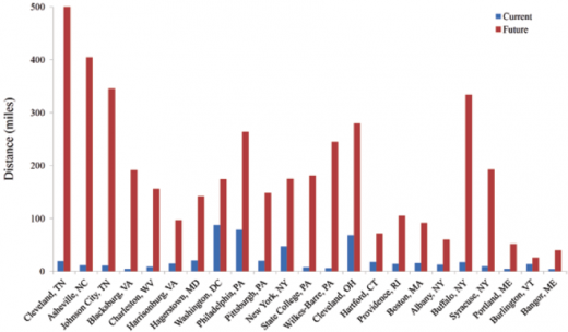
In a brilliantly simple approach, they then used Google Maps to calculate how far people in 23 eastern cities would have to drive to get to the 10 nearest brook trout streams, and came up with an average travel distance from each city to fish for brook trout. The results are stunning. Currently, across these 23 cities the average trip to a brook trout stream ranges between 4 and 87 miles. In 70-80 years, the distance to reach a brook trout stream is predicted, on average, to increase almost 164 miles. Yes, 164 miles, with anglers in the south fairing the worst. And once anglers they get there, they will need to be prepared for a hike, as many of the remaining brookies will likely be plying the cooler waters at the top of the watershed.

Helen Neville works for TU’s Science Team. She is based in Boise.


